Overview
| Location | Inyo County, California |
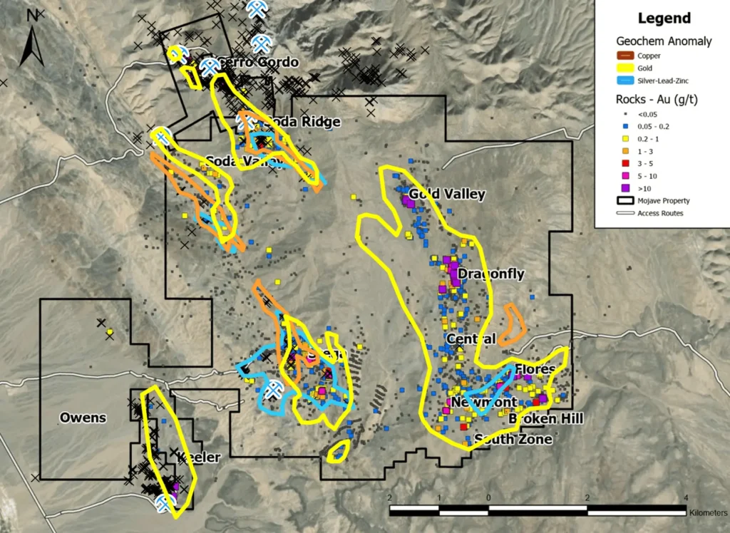
| Land Package | Over 5,830 Ha of prospective ground with more than 12 exploration targets. |
| Mineralization | Mineralization ranges from distal sediment-hosted oxide gold occurrences (Eastern Target Area) to proximal sediment-hosted Cu, Ag-base metal veins, polymetallic (Au-Ag-Cu-Pb-Zn) skarn, and potential Cu-Au porphyry occurrences on the western side of the property. |
Multiple oxide gold targets beginning at surface have been successfully historically drilled at the project, most notably by Newmont and BHP.
MPM has completed geochemical and geophysical surveys, geologic mapping, LiDAR, a WorldView 3 alteration survey, and successfully completed a 17-hole RC drilling program focused on the Dragonfly and Newmont Zones (the Eastern Target Area).
Highlights from the phase 1 drill program include:
- 4.0 g/t Au over 86.9m from surface at the Dragonfly Zone,
- 1.69 g/t Au over 41.15m from 44.20m down hole at the Newmont Zone
Sampling at the Gold Valley target, located 1.5km north-northwest along the same structure as the Dragonfly target returned:
- Grab samples of 208 g/t (6.7 oz/t) gold
- Initial prospecting samples of 32.1 g/t gold
Mojave hosts a range of mineralization likely related to a buried pluton identified by VTEM and aeromagnetic geophysics. The pluton is believed to be the heat engine responsible for distal sediment-hosted oxide gold occurrences, to proximal sediment-hosted base metal veins, polymetallic skarn, and potential copper-gold porphyry occurrences on the west side of the property.
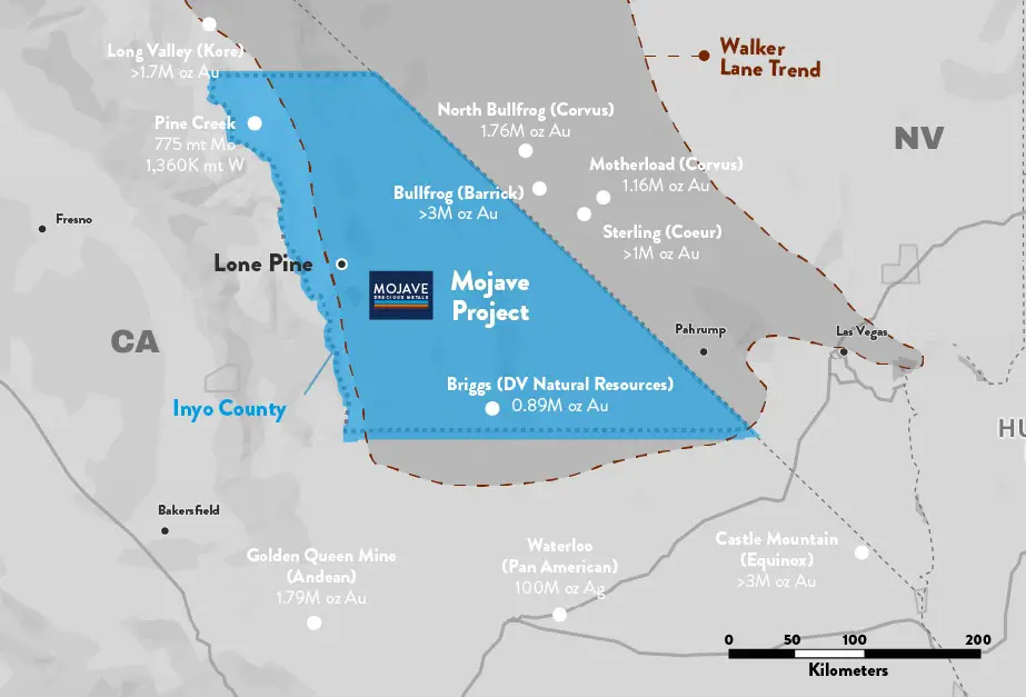
Location & Access
The project is located in west-central Inyo County, approximately 5.5 km east of Keeler, California, and 25km southeast of Lone Pine, California. It is accessible via existing gravel roads. Multiple historical drilling programs utilized a network of drill access roads which lead to the target areas and would allow for no new disturbance upon reactivation.
History
The southern Inyo Mountains and Cerro Gordo Mining District have a lengthy history of exploration and mining, with initial exploration in the area dating back to the 1860’s. Silver was discovered at the Cerro Gordo Mines area 1.5km north of the Mojave Property in the early 1860’s, with mining and smelting operations beginning in 1865.
Ore-bearing veins in the Santa Rosa area were discovered in 1910, leading to a mining operation 5km southeast of the property which ran from 1911 to 1938 with a brief hiatus from 1912 to 1915.
Historical workings surround the project area, including the previously mentioned Cerro Gordo Mine (lead, zinc, silver deposits), the Morning Star Mine (gold, silver, copper, zinc in marble) immediately north of the project, the Keeler Mine (gold-silver veins) 1.5km southwest of the property, and the Santa Rosa Mine (lead, zinc, copper veins) 5km to the southeast.
MPM's Work
Since acquiring the property in 2019, the Company has completed geochemical and geophysical surveys, geologic mapping, LiDAR and WorldView-3 surveys.
A 17-hole, 2,540m RC drilling program focused on the Dragonfly and Newmont Zones which includes highlights as follows:
- DF20-002: 6.68 g/t Au over 45.72m from surface
- DF20-004: 7.18 g/t Au over 30.48m from surface
- NM20-011: 1.69 g/t Au over 41.15m from 44.20m down hole
- NM20-016: 1.00 g/t Au over 22.86m from 42.67m down hole
Overview of target areas at the Mojave Project